Koindu, Kissy Teng Chiefdom, Kailahun District
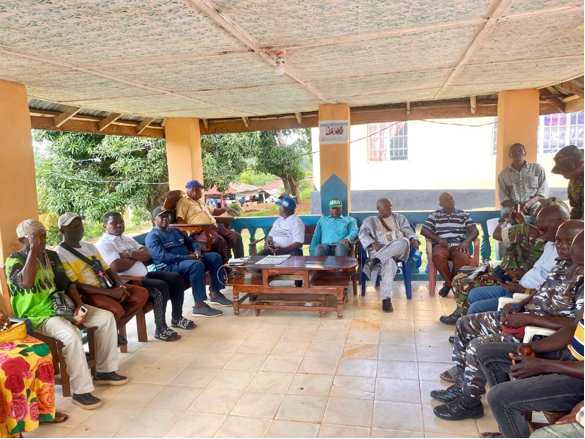
22nd June 2025 — In a significant step toward Sierra Leone’s preparation for the 2026 Population and Housing Census, Statistics Sierra Leone (Stats SL) has engaged traditional and local stakeholders of Kissy Teng Chiefdom in a sensitization meeting on the ongoing Pilot Cartographic Mapping exercise. The meeting was held in Koindu, the chiefdom’s administrative headquarters, drawing wide community participation and underscoring the importance of local ownership in the census planning process.
The engagement brought together a host of influential voices, including Paramount Chief Emmanuel Sahr Ganawah, all five Section Chiefs representing Konio, Bumasadu, Lela, Kundu, and Torli, Member of Parliament Hon. Ing. Fallah Kenewah Tengbeh, and a range of other key actors such as the Chiefdom Speaker, Mammy Queen, youth and women leaders, representatives from the Office of National Security (ONS), the Sierra Leone Police, the Republic of Sierra Leone Armed Forces (RSLAF), and members of the local motorbike riders union.
The opening remarks by Chief Elliot Fayah Foryoh set the tone for the meeting. He warmly welcomed the mapping teams from Stats SL and declared the chiefdom’s readiness to provide all necessary support to ensure a successful pilot.
“The mappers are more than welcome and will be given every necessary support to carry out their work,” Chief Foryoh assured, signaling strong local backing.
Backing up this sentiment, Hon. Ing. Fallah Kenewah Tengbeh expressed his delight that Kissy Teng was selected as one of the four pilot locations nationwide. He emphasized the strategic importance of engaging local populations and ensuring their full understanding of the process.
“We must ensure that our people understand and support the cartography process. I will continue to rally our stakeholders to ensure full cooperation,” he pledged, while also urging for more community-centered communication throughout the mapping phase.
Despite the strong support expressed, the meeting also surfaced longstanding concerns about the status of Yenga—a border town currently under the control of Guinean troops. Paramount Chief Emmanuel Sahr Ganawah voiced his worry over whether Yenga would be included in the mapping of Kissy Teng Chiefdom, given its unresolved territorial status.
“Yenga is part of my chiefdom, but it remains inaccessible due to the presence of Guinean forces. How will it be mapped?” he questioned, raising a critical issue that links national planning with cross-border diplomacy.
Responding to these concerns, Silleh Bah, Principal Statistician and Cartographer at Stats SL, assured participants that Yenga remains officially part of Sierra Leone based on national maps and geographic coordinates.
“Yenga, approximately 2.5 miles from Koindu, will be mapped as part of Kissy Teng Chiefdom,” Bah confirmed.
He went on to explain that while field teams may not be able to access Yenga physically, Stats SL has advanced technical solutions in place. High-resolution satellite imagery from ESRI will be used to capture detailed features of the town, including structures, roads, and population estimates.
“Should physical access remain restricted, Stats SL will use satellite data to project Yenga’s population and infrastructure. However, we are hopeful the boundary issue will be resolved before the national rollout,” he added.
Samuel Ansumana, Director of Communications and Public Relations at Stats SL, stressed the purpose of the engagement—community awareness and inclusive participation. He emphasized that effective communication is key to ensuring that every segment of society understands the relevance and implications of the mapping exercise.
“This exercise is not just technical; it’s about trust and cooperation. We want our local stakeholders to help spread the message in ways that resonate with their communities,” he said.
He urged participants to share the information with their constituents and to help Stats SL identify the most effective local communication channels to ensure the census message reaches even the most remote areas.
Traditional authorities, women’s groups, youth leaders, and other community representatives present at the meeting emphasized the need for sustained sensitization and follow-up activities. They argued that effective local involvement is not only vital to the success of the cartographic exercise but is also crucial to ensuring that the full census process accurately reflects ground realities.
Many urged Stats SL to organize more engagements in individual sections and to involve local champions, such as religious leaders and teachers, who have influence and reach across different segments of the community.
The Pilot Cartographic Mapping is part of Stats SL’s preparatory activities for the 2026 Population and Housing Census. It is currently being conducted in four distinct locations:
• Kissy Teng Chiefdom, representing a border-disputed area
• Dema Chiefdom, representing a hard-to-reach terrain
• Mara Chiefdom, an easily accessible rural zone
• Freetown East 3, a densely populated urban area
The pilot aims to test field tools and methodologies, gather operational feedback, assess logistical and geographical challenges, and provide training to mapping teams. The data and insights gathered from this pilot will inform the national rollout strategy, ensuring that future fieldwork is more effective, efficient, and inclusive.
As Sierra Leone prepares for what promises to be a landmark national census in 2026, Stats SL’s proactive engagement with communities like Kissy Teng is setting the tone for transparency, participation, and informed national planning.
© Stats SL Communications & Public Relations Unit